
Baja California Sur Civil Protection keeps watch on Simon as Tropical Storm Trudy forms
The state council expects rain in southern BCS from the Category 1 hurricane. Sinaloa watches were dropped in the afternoon, and Depression 21-E is now a tropical storm.
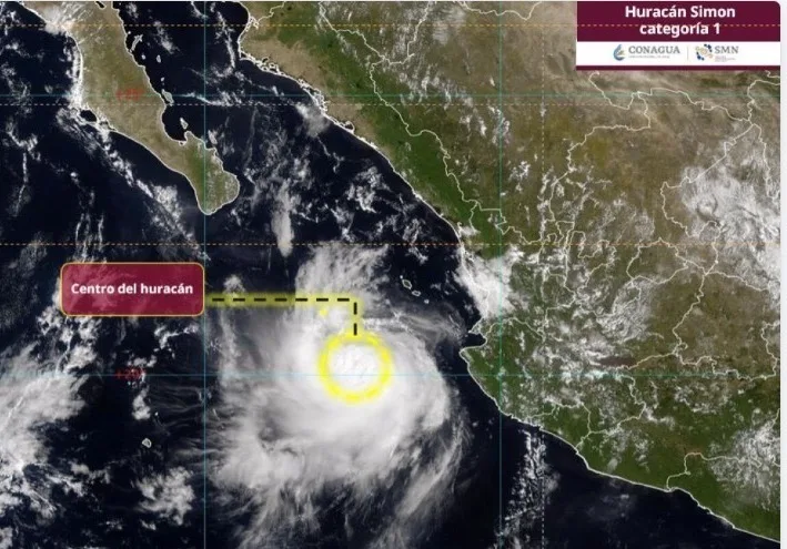
Baja California Sur's State Civil Protection Council is keeping a permanent watch on Hurricane Simon because of the rain forecast for the southern part of the state, the state government said on Tuesday, October 13. No hurricane watch or warning is in effect for the peninsula, and a second system formed in the afternoon: Tropical Storm Trudy, off Oaxaca and Guerrero.
What the state council reported
Citing Mexico's National Weather Service (SMN) report from 11 a.m., the council placed Simon as a Category 1 hurricane on the Saffir-Simpson scale, 180 kilometers west of Cabo Corrientes, Jalisco, and 350 kilometers south-southwest of Mazatlán, Sinaloa. The storm had maximum sustained winds of 150 km/h and gusts up to 185 km/h.
The council urged residents to stay informed through official channels and follow the authorities' recommendations, and to take precautions against possible rain and flooding. It said it will activate response protocols if needed.
How the picture changed in the afternoon
In its 2 p.m. MST advisory, the U.S. National Hurricane Center (NHC) said Simon was still nearly stationary, drifting west at about 3 km/h (2 mph), with a central pressure of 977 millibars. Mexico discontinued the hurricane and tropical storm watches on the mainland coast; only the hurricane watch for the Islas Marías remains.
The rainfall outlook for parts of Baja California Sur, Nayarit and Sinaloa is unchanged: 25 to 50 millimeters (1 to 2 inches), with isolated totals of 75 millimeters (3 inches), through Friday, October 16. The NHC still expects a turn to the north or north-northwest late in the week and asked people on the peninsula to monitor for possible future watches.
Trudy, the system to watch next
Tropical Depression 21-E strengthened into Tropical Storm Trudy. At 3 p.m. CST it was about 790 kilometers (490 miles) south-southeast of Acapulco, with winds of 65 km/h (40 mph), moving northwest at 13 km/h (8 mph).
The NHC expects Trudy to intensify rapidly, becoming a hurricane by Wednesday night and a major hurricane by Friday. There are no coastal watches yet, but its swells should begin reaching southern Mexico late this week.
What to do in southern Baja California Sur
With two cyclones active in the Pacific, the next 72 hours are for calm preparation:
- Keep your emergency kit ready: water, canned food, flashlight, batteries, medication and documents in a waterproof bag.
- Clear rooftops and drains; secure water tanks, roofing sheets and loose objects.
- Do not cross arroyos or flooded dips, even if the water looks shallow.
- Stay out of the sea and away from rocky areas while swells and rip currents persist.
- Rely only on state and municipal Civil Protection notices, which announce temporary shelters if they open.
Report any emergency to 911.
Related
The Category 1 storm is barely moving 165 km west of Cabo Corrientes and could turn north late this week. Tropical Depression 21-E has also formed.
Municipal Civil Protection expects no direct hit on the peninsula, but high surf, gusts and light to moderate rain along the coast over the next 48 to 72 hours.
Palmilla, Acapulquito, Costa Azul, La Playa and Las Palmas are closed to swimming; the hyacinth came out of the San José del Cabo estuary after its sandbar opened naturally.
The tropical storm is about 1,500 km west of Los Cabos and would near the peninsula's northern coast on Saturday. Simon, off Colima, has prompted a hurricane warning for Michoacán and Jalisco.