
Simon becomes Category 4 far from Los Cabos; Rachel keeps warning north of Punta Eugenia
Municipal Civil Protection expects no direct hit on the peninsula, but high surf, gusts and light to moderate rain along the coast over the next 48 to 72 hours.
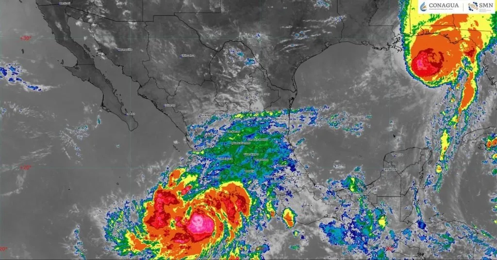
Hurricane Simon strengthened to Category 4 on Saturday, October 10, off the coasts of Colima and Jalisco, and Los Cabos Civil Protection said no direct impact on the Baja California peninsula is expected. Southern Baja California Sur should see light to moderate rain, high surf and wind gusts over the next 48 to 72 hours, mainly along the coast.
Meanwhile, Tropical Storm Rachel is moving northeast in the Pacific, with a tropical storm warning in effect for the peninsula's west coast from Punta Eugenia, in Mulegé municipality, to the U.S. border.
Where Simon is
According to the 9 a.m. CST advisory from the U.S. National Hurricane Center, Simon was 185 km (115 miles) south-southwest of Manzanillo, Colima, and 345 km (215 miles) south-southeast of Cabo Corrientes, Jalisco. It had maximum sustained winds of 240 km/h (150 mph) and was crawling north at 6 km/h (3 mph).
The hurricane warning covers the coast from Punta San Telmo, Michoacán, to El Roblito, Nayarit, including the Islas Marías. The heaviest rain, 250 to 500 mm (10 to 20 inches), is forecast for parts of Michoacán, Colima and Jalisco.
Municipal Civil Protection Director Francisco Cota Márquez said the system does not pose a direct threat to the peninsula. Mayor Christian Agúndez Gómez ordered continuous monitoring.
Rachel, the storm that already closed schools
Rachel is the same cyclone that led the State Civil Protection Council to suspend classes in Los Cabos in early October; schools reopened on Monday, October 5. At 8 a.m. PDT Saturday it was about 630 km (390 miles) southwest of Punta Baja, Baja California, with sustained winds of 95 km/h (60 mph), moving northeast at 35 km/h (22 mph).
The official forecast calls for landfall tonight and a transition to a post-tropical cyclone on Sunday. Life-threatening surf and rip currents are expected along the Pacific coast, along with 25 to 75 mm (1 to 3 inches) of rain, locally up to 125 mm (5 inches), in Baja California and the southwestern U.S.
What to do in Los Cabos and the rest of the state
Civil Protection urged residents to rely only on official channels, take extreme care at beaches, avoid crossing arroyos and skip risky activities while the surf remains high.
- At the beach: obey red flags even under clear skies; swells from a distant hurricane arrive before the clouds.
- Arroyos: do not cross on foot or by car if water is flowing, even if it looks shallow.
- Fishers and boat operators: check with the Port Captain's office before heading out.
- Northern Pacific coast of Mulegé: communities around Punta Eugenia and the Vizcaíno area should follow Rachel advisories overnight.
The eastern North Pacific hurricane season runs through November 30, so monitoring will continue in the coming weeks.
Related
Palmilla, Acapulquito, Costa Azul, La Playa and Las Palmas are closed to swimming; the hyacinth came out of the San José del Cabo estuary after its sandbar opened naturally.
The tropical storm is about 1,500 km west of Los Cabos and would near the peninsula's northern coast on Saturday. Simon, off Colima, has prompted a hurricane warning for Michoacán and Jalisco.
Published in Official Bulletin No. 37, the document coordinates the Search Commission, prosecutors, Civil Protection, the armed forces and police.
The city continues its preventive operation in Cabo San Lucas and urges residents not to cross arroyos or runoff channels on foot or by car.