
Rachel strengthens to Category 3; forecast rain for southern Baja California Sur raised to 150 mm
The hurricane was 390 km south of Cabo San Lucas at 3 p.m.; waves of 4 to 6 meters are forecast along the state's coast.
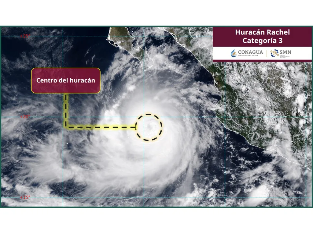
Hurricane Rachel strengthened to Category 3 on Thursday afternoon, October 1, with sustained winds of 195 km/h (120 mph) and gusts of 240 km/h. According to advisory 37 from Mexico's National Weather Service (SMN), issued at 3:00 p.m., its center was 390 km (about 245 miles) south of Cabo San Lucas.
With the update, the SMN forecasts locally intense rain of 75 to 150 mm in southern Baja California Sur. In the morning, state authorities were working with 50 to 75 mm, so the upper end of the forecast has doubled.
What changed since the morning
At 8:00 a.m. Rachel was a Category 2 with 165 km/h winds and a pressure of 964 mb. Seven hours later, the U.S. National Hurricane Center reported a minimum pressure of 950 mb, a sign the system had intensified.
The SMN expects it to reach Category 4 around midnight Friday, October 2, before gradually weakening. It is moving very slowly, west at about 6 km/h, so its effects on the sea and its rain bands may last longer.
What to expect in the south of the state
- Rain: locally intense, 75 to 150 mm.
- Waves: 4 to 6 meters along the Baja California Sur coast.
- Wind: 40 to 50 km/h, with gusts of 60 to 70 km/h.
As of 2:00 p.m. local time, the National Hurricane Center listed no coastal watches or warnings. Hurricane-force winds extend about 40 miles (65 km) from the center and tropical-storm-force winds up to 150 miles (240 km).
Why it matters even with the eye offshore
150 mm of rain in a few hours is enough to make arroyos run in San José del Cabo, Cabo San Lucas and the tourist corridor. The risk is higher because the ground is still wet after Polo in late September, when La Paz firefighters rescued 15 people trapped in the San Blas arroyo.
Waves of 4 to 6 meters can also affect low-lying coastal areas and make any activity at sea dangerous, even under clear skies.
What to do tonight
- Do not cross arroyos or flooded dips: most rescues in Baja California Sur involve vehicles swept away.
- If you live in a low area or next to an arroyo, find the nearest temporary shelter now and have your emergency bag ready.
- Secure sheet-metal roofs, water tanks and loose objects in yards and on rooftops.
- Store water: power outages can stop pumping and disrupt water rationing schedules.
- For emergencies or transport to a shelter, call 911.
The SMN issues advisories every three hours, and the next National Hurricane Center advisory is scheduled for 8:00 p.m. Any decision about Friday classes will be announced by the State Civil Protection Council.
Related
The storm reached Category 2 about 370 km south of Cabo San Lucas; 50 to 75 mm of rain is expected in southern Baja California Sur.
ZOFEMAT closed five beaches in San José del Cabo and nine in Cabo San Lucas; the rest of the municipality is under red or yellow flags.
On Wednesday the storm was 220 miles southwest of Cabo Corrientes with 85 mph winds and could become a major hurricane within 24 hours.
The State Civil Protection Council suspended all grade levels and both shifts in three municipalities ahead of rainfall of up to 150 millimeters.